A luxury home with ocean views can feel underwhelming if the listing only shows a living room, a kitchen, and a patio cropped too tight to explain the setting. Buyers are not just evaluating finishes. They are judging privacy, proximity, orientation, land, and the feeling of arrival. That is where drone photography for real estate listings becomes more than a visual extra. It gives context that ground-level photography simply cannot.
For agents, developers, and property owners selling high-value homes, aerial imagery can change how quickly a buyer understands the asset. For vacation homes, estates, gated properties, hillside residences, and homes near water, that context is often the difference between a listing that gets glanced at and one that earns serious attention.
Why drone photography for real estate listings works
Traditional real estate photography is still the foundation of a strong listing. Buyers want to see interiors clearly, understand flow, and assess condition. But ground-based images have limits. They rarely show how a home sits within the lot, how the property relates to the beach, golf course, town center, or mountains, or how much space surrounds it.
Drone photography solves that problem by adding perspective. A well-planned aerial image can show the full footprint of a residence, the shape of the land, mature landscaping, guest houses, outdoor living areas, and the route to nearby amenities. It helps buyers answer practical questions before they ask them.
That said, stronger does not always mean more. Aerial content is most effective when it is intentional. Five carefully chosen drone images usually do more than twenty repetitive overhead shots. The goal is not novelty. The goal is clarity, scale, and desire.
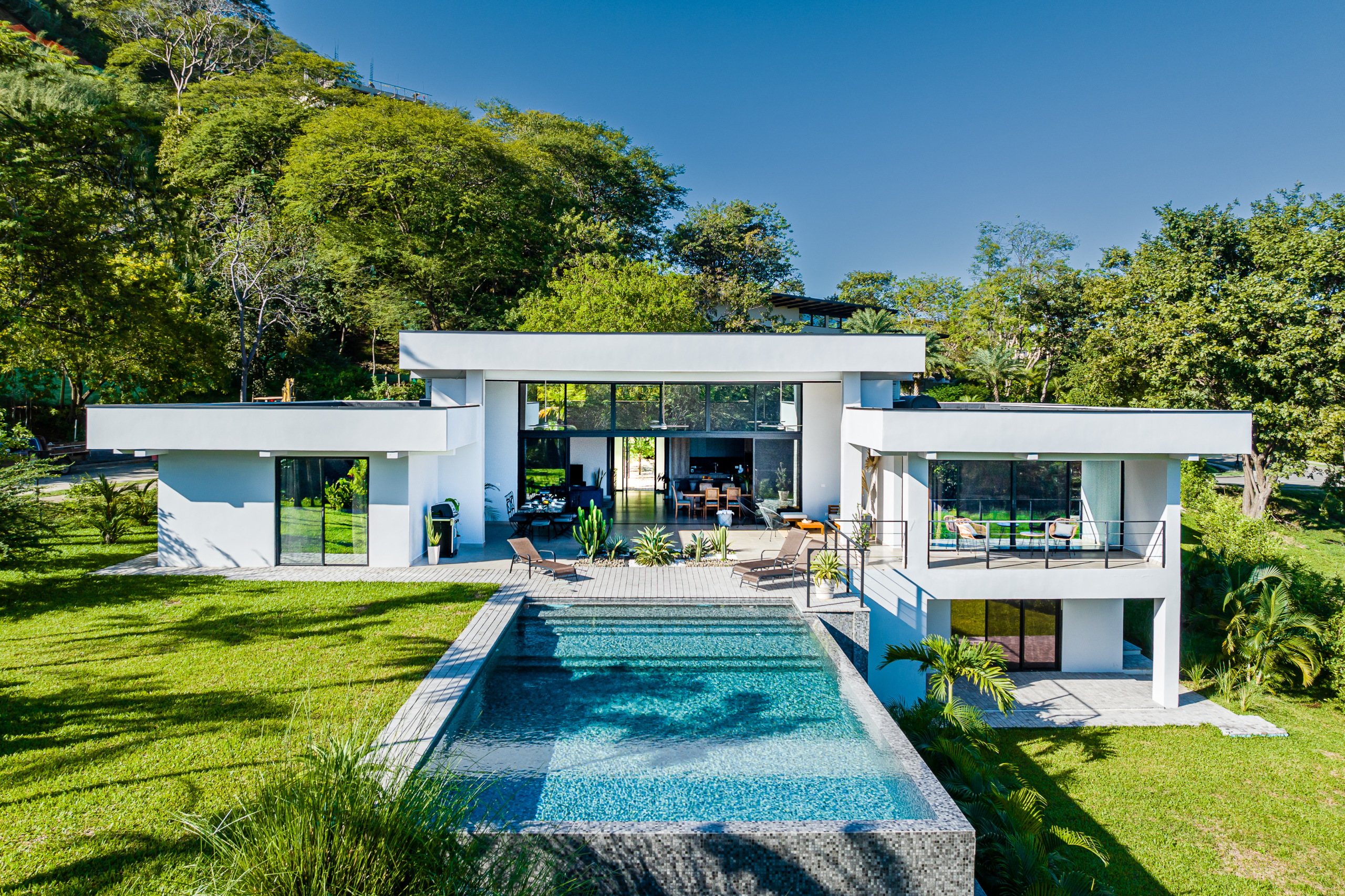
What buyers actually want to see from the air
The most valuable drone images are usually not the highest ones. Extremely elevated shots can look impressive, but they often reduce the home to a small object inside a large frame. For listing performance, the best images usually balance the property and its surroundings so buyers understand both.
A strong aerial set often includes an approach view, an angle that shows the main home in relation to the lot, a wider contextual image showing nearby features, and a shot that highlights outdoor amenities such as a pool, terrace, gardens, or direct access points. If the property has a defining advantage such as sunset orientation, beach access, ridge-top positioning, or proximity to a marina, that advantage should be obvious.
For luxury listings, this matters even more. High-end buyers are purchasing lifestyle as much as square footage. They want to see whether the home feels secluded or connected, elevated or tucked away, dramatic or understated. Drone imagery can answer those emotional questions quickly, especially when combined with refined architectural photography.
When aerial photography adds the most value
Not every property needs a large drone package. A compact suburban home in a dense neighborhood may benefit from one or two aerial images, but it may not need extensive coverage. On the other hand, certain properties almost demand it.
Homes with acreage, ocean views, mountain settings, multi-structure layouts, private roads, or standout outdoor design benefit immediately. So do vacation rentals and resort-area properties, where the surrounding environment helps sell the experience. In destinations like coastal Costa Rica, for example, the relationship between the property and the landscape is often central to the buyer decision. A home is rarely just a structure. It is a place within a setting.
Developers also gain value from aerial work because it shows progress, scale, layout, and location in one frame. For pre-sale marketing, drone imagery can establish credibility and give buyers a better sense of what is being built and why the site matters.
The difference between useful drone photos and weak ones
The barrier to entry for drone operation is low. The barrier to producing listing-ready aerial imagery is not. Many real estate listings include drone photos that feel generic, overedited, or poorly composed. They technically show the property, but they do not sell it.
Good drone photography depends on timing, composition, and local understanding. Light matters more than most people expect. Midday sun can flatten landscaping, create harsh roofs and pavement glare, and make a property feel sterile. Early morning or late afternoon often reveals texture, depth, and a more flattering sense of atmosphere.
Weather matters too. Coastal haze, strong wind, or an overly dramatic sky can either help or hurt depending on the home and the intended tone of the listing. The right photographer knows when to wait, when to adjust the shot plan, and when a cleaner image will outperform a more cinematic one.
Then there is post-production. Aerial images should look polished, but still truthful. Over-saturated water, fake skies, and unnatural greens may grab attention for a second, but they can also reduce trust. In premium real estate, buyers notice when imagery feels manipulated.
Video changes the pace of the listing
Still photography does the essential work of showing features clearly, but drone video adds movement and narrative. It can reveal the approach to the home, the transition from entry to view, or the way the property opens toward the landscape. For larger homes and destination properties, that motion helps the buyer feel the scale more intuitively.
This does not mean every listing needs a long, heavily produced film. Often, a short, elegant aerial sequence integrated into a broader property video is enough. The best real estate video feels calm, deliberate, and architectural. Fast spins, dramatic rises, and flashy effects usually age badly and distract from the property itself.
For agents marketing premium homes, the combination of interiors, exteriors, and restrained aerial video can elevate the entire presentation. It signals that the property is being handled professionally, and that perception affects more than aesthetics. It shapes buyer expectations before a showing is ever scheduled.
Legal, safety, and practical considerations
Drone work is not just about creativity. It also requires compliance, planning, and risk awareness. Flight restrictions, weather conditions, neighboring properties, and site-specific hazards all affect what can and should be captured. This is especially relevant in populated areas, coastal zones, or locations with aviation sensitivity.
A professional should know how to operate legally, protect privacy, and work safely around the property. They should also understand that the objective is marketing, not spectacle. If a home is close to neighbors, imagery should highlight the property honestly without creating avoidable privacy concerns or visual clutter.
This is one reason local knowledge matters. A photographer familiar with the region can better anticipate wind patterns, seasonal light, access challenges, and the angles that show a property at its best. In destination markets, that experience often makes the difference between footage that looks expensive and footage that actually performs.
How to plan drone photography for better listing results
The most effective shoots begin with a clear strategy. Before the drone goes up, it helps to identify what makes the property distinct. Is it the lot size, the view corridor, the beach proximity, the pool deck, the guest casita, the privacy, or the architectural footprint? The aerial plan should support that story.
It also helps to coordinate the property styling with the flight schedule. Outdoor furniture should be placed thoughtfully, umbrellas opened if appropriate, vehicles moved, landscaping cleaned, and pool surfaces checked. These details are visible from above, and they affect how finished the listing feels.
Agents should also think about where the aerial content will be used. MLS needs are different from social media teasers, paid campaigns, brochure design, and property websites. A smart creative team captures with those uses in mind, so the material works across formats instead of existing as a disconnected add-on.
Studios that specialize in premium visual marketing, including teams like BiDrop, often approach drone imagery as part of a larger listing system rather than a separate service. That matters because the best results come from consistency. The aerial content should match the tone, quality, and pacing of the interior photography, video, and virtual assets.
Is drone photography always worth it?
Usually, but not automatically. It depends on the property, the market segment, and the quality of execution. If the aerial imagery is poorly planned or the home has little to gain from a higher viewpoint, the return may be modest. If the property has a strong setting, meaningful land value, or an experience-based appeal, drone photography can be one of the most persuasive assets in the listing package.
The more expensive the property, the more buyers expect a polished visual presentation. They may not specifically ask for drone work, but they respond to listings that communicate confidence, completeness, and care. Aerial imagery helps create that impression when it is done with restraint and purpose.
A beautiful property deserves more than proof that it exists. It deserves visuals that explain why it matters, how it lives, and what makes it difficult to replace. When drone photography is approached with that level of intention, it stops being a trend and becomes part of how exceptional listings are sold.